


We have to double-check your registration and make sure this is not an automated entry in our system. Please complete the test below...
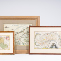
Three maps relating to a.o. Poland, Lithuania, Zuidbeveland, Bruges, Ostend, hand-coloured copper engravings, 18th C.

785
(1) Willem Tiberius Hatinga (1700-1764), 'Kaart van het eiland Zuidbeveland, op ordre van Z.D.H. W.C.H. Friso Prinse van Oranje ...', published by Isaak Tirion, Amsterdam, 1753.
Work: 62,5 x 32,5 cm
Frame: 83,5 x 54 cm
(2) Eugène Frickx (1644-1730), 'Carte particuliere des environs de Bruges, Ostende, Damme, L'Ecluse et autres...', published by Pieter Mortier, Amsterdam, ca. 1715.
Work: 56,5 x 44 cm
Frame: 86,5 x 74 cm
(3) Christoph Weigel (1654-1725), 'Poloniae & Lithuania accurante curatius', published by Johann Ernst Adelbulner, Nuremberg, 1718. Scarce map of Poland and the Baltic States, showing the area from the Baltic Sea to the Black Sea with Poland, Estonia, Latvia, Lithuania, Belarus and Ukraine.
Work: 34 x 27,5 cm
Frame: 51 x 45,5 cm
Estimate:
€ 200
-
€ 400