


We moeten verifiëren dat uw registratie niet om een geautomatiseerde ingave in ons systeem gaat. Vervolledig aub de onderstaande test...
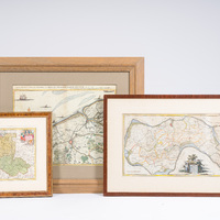
Drie kaarten met betrekking tot o.m. Polen, Litouwen, Zuidbeveland, Brugge, Oostende, handingekleurde kopergravures, 18de eeuw

785
(1) Willem Tiberius Hatinga (1700-1764), 'Kaart van het eiland Zuidbeveland, op ordre van Z.D.H. W.C.H. Friso Prinse van Oranje ...', published by Isaak Tirion, Amsterdam, 1753.
Work: 62,5 x 32,5 cm
Frame: 83,5 x 54 cm
(2) Eugène Frickx (1644-1730), 'Carte particuliere des environs de Bruges, Ostende, Damme, L'Ecluse et autres...', published by Pieter Mortier, Amsterdam, ca. 1715.
Work: 56,5 x 44 cm
Frame: 86,5 x 74 cm
(3) Christoph Weigel (1654-1725), 'Poloniae & Lithuania accurante curatius', published by Johann Ernst Adelbulner, Nuremberg, 1718. Scarce map of Poland and the Baltic States, showing the area from the Baltic Sea to the Black Sea with Poland, Estonia, Latvia, Lithuania, Belarus and Ukraine.
Work: 34 x 27,5 cm
Frame: 51 x 45,5 cm
Geschat:
€ 200
-
€ 400